
01 / Start here
Start here
Torre (1,993 m) is the highest point of mainland Portugal, on the Serra da Estrela plateau. It is reached by road when access is open, so a visit can be a short stop or the starting point for a wider mountain journey. Portugal’s highest mountain overall is Pico in the Azores. The plateau is exposed, and a convenient road does not guarantee safe access in snow, fog or strong wind. ICNF park information ↗.
02 / Choose your visit
Choose your visit
Road visit: drive to the plateau, park where permitted and walk around the public summit area. Regional touring: combine Torre with Lagoa Comprida, a village or a viewpoint, allowing for mountain roads. A hike: select a separately described route with a verified start, finish and return transport. These options have different demands: do not use a road-visit estimate for a mountain trail.
03 / At the summit
At the summit
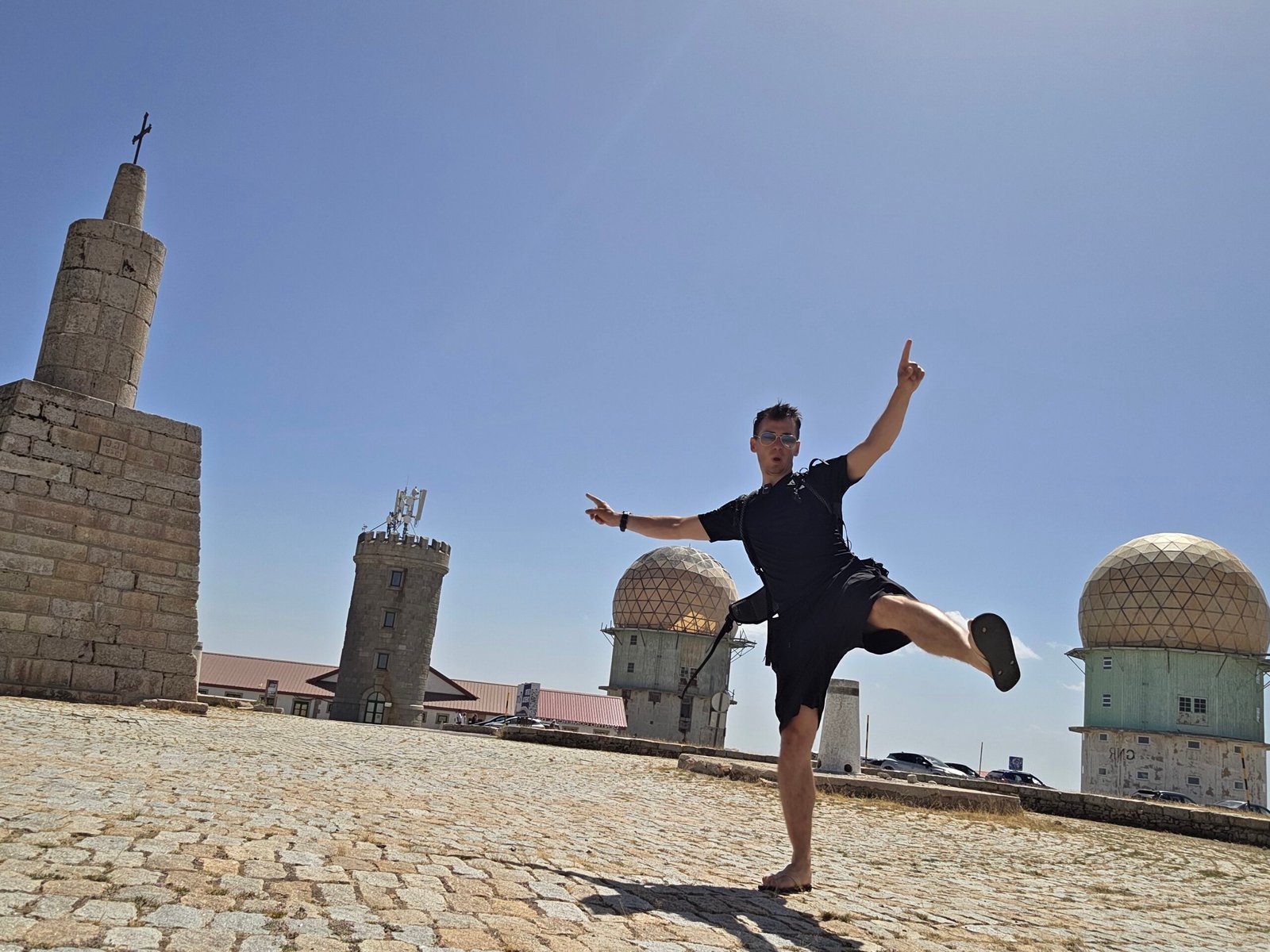
The broad plateau has a stone monument and distinctive domed structures. The landscape is unlike a narrow, pointed summit. Stay aware of traffic around the paved area, use designated public access and avoid entering restricted buildings. Visibility can disappear rapidly; save viewpoints for a clearer day.

04 / Road from Seia
Road from Seia
Portugal’s tourism authority describes an approach through Sabugueiro and Lagoa Comprida as one option from Seia. It is a mountain road: allow time for bends, other traffic and changing visibility. Check the exact route and the current road status before driving; do not assume that a navigation app knows a temporary closure. Visit Portugal itinerary ↗.
05 / Road from Covilhã
Road from Covilhã
Covilhã is another useful gateway to the eastern side of the range. Visit Portugal identifies the A23 access to Covilhã and the roads linking it with Seia across the mountains. Confirm the particular road you intend to use and its condition on the day. Winter restrictions or incidents can affect individual sections. Regional transport overview ↗.
06 / Road closures
Road closures
Snow, ice, fog, wind, wildfire response or emergency operations can change access. Check the latest instructions from the relevant authorities and local park contacts, obey barriers and signs, and postpone if the road is closed. A previously open route is not a promise of access today. Do not attempt to drive around a closure.
07 / Parking and facilities
Parking and facilities
Use marked parking and leave space for emergency vehicles, buses and pedestrians. Conditions can be crowded in snow season; arrive with a backup plan and do not park on verges where prohibited. Check shops, toilets, opening hours and accessibility directly before travelling rather than assuming that facilities are open.
08 / Visit on foot
Visit on foot
The short walk around the developed summit area is different from hiking across the plateau. Ground outside paved areas can be uneven and exposed. Choose footwear for the conditions, stay within public areas and turn back if poor visibility or icy ground makes even a short walk unsafe.

09 / Loriga glacial valley
Loriga glacial valley
For an experienced walking group, a Geopark educational programme describes a difficult one-way 9 km route from Torre plateau to Loriga through the glacial valley. This is not a round trip and the programme is not a current guarantee of trail condition or waymarking. Check the exact route, closures and weather with local authorities, arrange transport back and allow a realistic margin. Estrela Geopark programme ↗.
10 / Other walks
Other walks
Covão da Ametade and the Zêzere valley offer opportunities to explore the glacial landscape, but paths differ in difficulty and may not lead to Torre. Ask the park or Geopark for a current route description suited to your group; carry a map and confirm access, distance, climb and return before starting. Serra da Estrela visitor information ↗.

12 / Getting to the region
Getting to the region
Seia, Covilhã and Manteigas are useful bases on different sides of the mountains. The best choice depends on your chosen road and activities. Allow extra time for the final mountain section and avoid driving tired after a flight. Verify current conditions instead of relying on my journey time.

13 / Public transport
Public transport
Portugal’s tourism authority lists rail services to Covilhã and coaches to regional towns including Seia and Covilhã. A connection to a town does not imply a bus reaches Torre. Check current timetables with CP ↗ and Rede Expressos ↗, and arrange the last leg and return before travelling. Visit Portugal transport overview ↗.
14 / Where to stay
Where to stay
Seia works well for the western approaches, Covilhã for the eastern side and Manteigas for the Zêzere valley. Check accommodation location, parking, opening and winter road access directly. A stay below the plateau can make it easier to wait for a better forecast instead of rushing a long day trip.
15 / Season
Season
Summer can bring sun and dry ground but also heat, thunderstorms and limited shade. Winter can transform the plateau into snow and ice; roads may be restricted. Spring and autumn are changeable. Choose your activity by actual conditions, not the calendar alone.
16 / Weather and visibility
Weather and visibility
Check IPMA forecasts and warnings ↗ shortly before leaving, then look for local high-ground information. A forecast for a valley town is not a reliable measure of wind or visibility at Torre. If cloud, wind, lightning or road conditions deteriorate, change your plan early.
17 / Winter driving
Winter driving
Snow and ice require careful preparation and may close the road altogether. Follow official instructions about permitted access and vehicle equipment; ask your rental provider what is allowed and covered. Carry warm clothes and supplies in the vehicle. A four-wheel-drive vehicle does not authorise passage beyond a closure.
18 / Mountain safety
Mountain safety
Roadside access does not remove exposure to cold, wind, sun and sudden weather changes. For a hike, choose a route within your group’s experience, share your plan and return time, carry navigation, food, water and layers, and leave enough daylight. Conditions can make an apparently gentle plateau demanding.
19 / Emergency
Emergency
In Portugal call 112 in an emergency. Give the operator your location, nature of the incident, number of people and conditions, then follow instructions. Mobile coverage can be unreliable in the mountains; carry a charged phone and power bank, and tell someone your planned return. Portugal emergency information ↗.
20 / Water and food
Water and food
Take drinking water and food appropriate to the length of your outing, plus a reserve for delays. Do not assume that a mountain shop, café or water source will be open or suitable to drink. Refill and buy supplies in your base town before heading up.
21 / Protect the park
Protect the park
Serra da Estrela is a protected landscape with fragile upland habitats and glacial features. Keep to appropriate paths, carry rubbish out, respect wildlife and grazing animals, and follow current fire and park rules. Never light a fire where prohibited or treat an unverified bivouac location as authorised. ICNF park information ↗.

22 / Lagoa Comprida
Lagoa Comprida
Lagoa Comprida lies on a scenic approach from Seia. It can make a useful stop on a road itinerary, subject to parking and access rules. Reservoir edges, slippery rocks and sudden weather changes deserve care; check official information and do not assume swimming or access is permitted everywhere. Visit Portugal itinerary ↗.
23 / Zêzere glacial valley
Zêzere glacial valley
The Zêzere valley and Covão da Ametade reveal the effects of past glaciation. Estrela Geopark describes the valley’s U-shaped profile and geological history. Choose viewpoints or a separately planned walk according to the weather and available time. Geopark interpretation ↗.
24 / Loriga and villages
Loriga and villages
Loriga’s glacial valley and river beach offer a different perspective on the range. Seia, Sabugueiro and Manteigas are useful places to explore local life. Check seasonal opening and access to individual sites and swimming areas before making plans. Loriga river beach ↗.
25 / Food and local culture
Food and local culture
Serra da Estrela is known for its sheep’s-milk cheese and pastoral traditions. Allow time for a meal in a village or town, and check opening hours directly. The park’s official visitor information explains the region’s sheep, working dogs and cheese-making heritage. Visit Portugal: natural park ↗.
26 / A flexible itinerary
A flexible itinerary
One day: travel to the region, visit Torre if the road and weather allow, and stop at a suitable viewpoint before returning. Two days: stay in a gateway town, add a village or a separately planned walk, and keep a weather alternative. Winter or poor visibility may require an entirely lower-altitude plan.

27 / Costs
Costs
Budget for travel, tolls, fuel, accommodation, food, parking or activities where applicable, and insurance. Check current quotes and terms with providers: no fixed price is guaranteed here. The calculator accepts your own amounts in euros and separates shared travel from personal spending.
Enter your own prices in euros. Vehicle and main travel are shared; the other amounts are per person. Blank entries count as zero.
28 / Saved checklist
Saved checklist
Saved only in this browser.
29 / My visit
My visit
I visited Torre on 8 August 2025. Before that, after Coma Pedrosa I drove back to Barcelona El Prat, returned the car and flew to Lisbon. I rented a small Avis car and drove north the following morning. It struggled on the hills, and the long journey felt exhausting; central Portugal’s olive groves, dry fields and villages offered a quieter landscape along the way.
After nearly five hours of driving I reached Serra da Estrela. At 14:45 I arrived at Torre. I walked around the summit area and visited nearby viewpoints in warm, clear weather. After weeks of intense climbs, airports and nights in cars, the quiet plateau felt almost unreal: blue sky, stillness and a rare chance to slow down.
The drive had been long and the car frustrating, but the calm at the top gave me perspective. Not every expedition day has to be measured in physical effort; some moments matter because they let you pause. My journey and time are personal recollections, not travel-time estimates for other visitors.

30 / Questions answered
Questions answered
Is Torre Portugal’s highest mountain?
It is the highest point in mainland Portugal. Pico in the Azores is higher.
Can I drive to the top?
A road reaches the summit area when open, but closures and restrictions can occur. Check current conditions and obey signs and barriers.
Do I need to hike?
No long hike is required for a road visit when access is open. Hikes elsewhere in the mountains require separate planning.
Is it safe in winter?
Conditions can include ice, snow, low visibility and closures. Check official advice and your equipment, and postpone when conditions are unsuitable.
Sources and current information
Research checked 2 November 2026. Conditions and services can change.
- ICNF park information ↗
- Visit Portugal itinerary ↗
- Regional transport overview ↗
- Estrela Geopark programme ↗
- Serra da Estrela visitor information ↗
- CP ↗
- Rede Expressos ↗
- Visit Portugal transport overview ↗
- IPMA forecasts and warnings ↗
- Portugal emergency information ↗
- Geopark interpretation ↗
- Loriga river beach ↗
- Visit Portugal: natural park ↗