
01 / Start here
A high point with a boundary.
A region worth discovering.
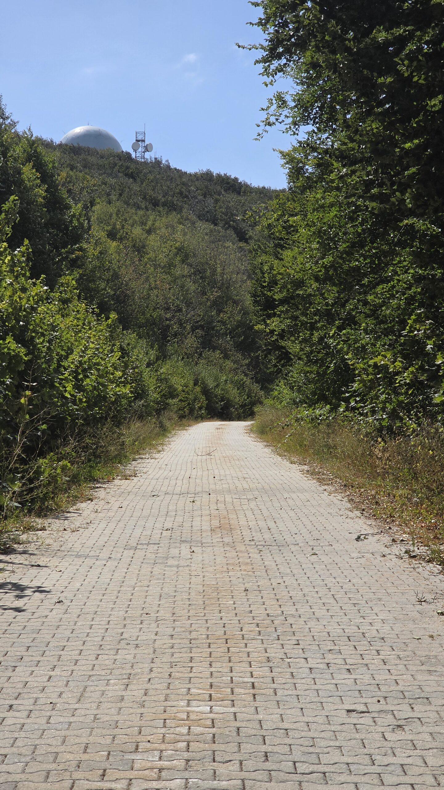
Mahya Dağı, approximately 1,031 m, is the highest point of European Türkiye, in the Istranca or Yıldız Mountains of Thrace. It is not the highest mountain of Türkiye as a whole.
The summit area is reported to be controlled for military use. Public access to the summit cannot be assumed. Check current boundaries and permissions with the competent local authorities; respect signs, barriers and instructions and do not enter a restricted area. Regional visitor overview.
- Height
- 1,031 mEuropean Türkiye’s high point
- Range
- Istranca / YıldızThrace and Kırklareli region
- Summit
- Restricted areaConfirm current access
- My visit
- 14 August 2025Stopped outside the controlled area
- Best plan
- Regional tripForests, coast and heritage
- Emergency
- 112Türkiye emergency service
02 / Summit access
The highest point is not an ordinary trail destination.
A regional visitor overview reports a controlled military area at the summit. The exact boundary and rules can change and are not established by a map or a past visit. Do not plan a walk to the top unless the competent authority confirms that your intended destination and access are permitted. Read the regional overview.
03 / Check access
Ask before travelling.
Contact the Kırklareli governorship or the relevant local authority to establish where visitors may go, whether any authorization is available for your nationality and intended activity, and what current restrictions apply. Written information and signs on site take precedence over a traveller’s old account. Kırklareli Governorship.
Türkiye has legislation governing military restricted and security areas; the applicable classification and permissions at a particular location must be confirmed with the authorities. Official legislation.
04 / A legal visit
Choose a permitted destination.
This guide does not offer a summit route, a suggested point at which to leave a car, or a track through the controlled area. If access is not clearly confirmed, visit an established public attraction elsewhere in the region instead. A legal alternative can still make a memorable Thrace trip.
05 / Signs and barriers
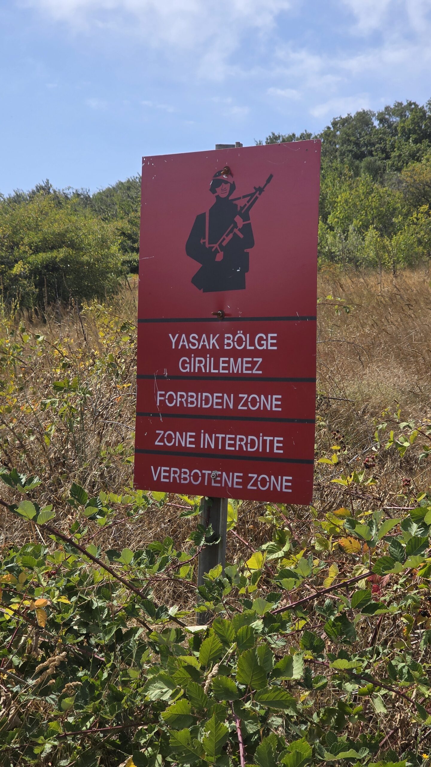
Stop where access is restricted.
Never cross a gate, fence or warning sign, and follow instructions from authorised staff. A previous visitor’s stopping point does not establish the boundary today. Ask the relevant authority about photography and drone rules before using a camera near any controlled area.
06 / Plan your day
Build the day around what is open.
First confirm a permitted destination and its access. Then check weather, driving time, parking and daylight. If access cannot be confirmed, switch to İğneada, Dupnisa or a cultural visit in Kırklareli, each planned separately with current opening information.
07 / Getting to Thrace
Allow time beyond Istanbul.
European Türkiye’s Thrace region includes Kırklareli, useful as a base for the Istranca area. Compare your route and travel time from Istanbul with current road conditions. My own 2025 drive is a personal account, not a measured or current journey estimate.
08 / Driving safely
A remote road needs a return plan.
Use verified public roads and follow local instructions. Fill up before rural travel, download maps and check your rental agreement. Road works, weather and access restrictions can change; a navigation app cannot grant access to a closed road.
09 / Parking
Park only where allowed.
For a confirmed public destination, ask locally where visitors may park. Do not block gates, working roads or emergency access. If parking or access is uncertain, choose another destination rather than improvising near a restricted area.
10 / Public transport
Arrange the last leg.
Search current coach and rail services to the wider region, then confirm local transport to the specific attraction. Do not assume there is public transport to a remote forest destination. Ask operators and accommodation providers about current timetables, pickup and return. Turkish rail passenger information.
11 / Where to stay
Choose your base for the wider region.
Kırklareli can serve a cultural and regional itinerary; İğneada or Kıyıköy may suit a coastal stay. Check the actual location, seasonal opening, parking, meal options and cancellation terms directly. Distances and driving times depend on your chosen route.
12 / When to visit
Match the season to the place.
Spring and autumn can offer a different forest experience from a hot summer day; wet weather changes road and walking conditions. Check opening and any fire or protected-area restrictions before setting out. A calendar season does not guarantee summit access.
13 / Weather
Check the forecast for your actual trip.
Use the Turkish meteorological service for current conditions and warnings. Its Kırklareli town forecast is not a summit forecast: exposed uplands can be cooler, windier or mistier. Adjust a walk or drive to the conditions on the day. Kırklareli forecast.
14 / Food and water
Bring supplies for rural travel.
Buy drinking water and food before a remote outing and carry a reserve. Do not assume shops, restaurants or drinking water will be available at your chosen destination; check opening with the provider. Take all packaging back with you.
15 / Forest walks
Pick a public route with local advice.
Ask the provincial tourism office or protected-area managers for an open trail suited to your group and the day’s conditions. Confirm its start, full return, seasonal restrictions and any charges. Do not infer that an unmarked forest road or online track is open to visitors. Regional nature ideas.
17 / Safety
Treat a short walk seriously.
Wear footwear suited to the selected walk, carry water, weather protection, a charged phone and basic first aid, and tell someone where you are going. Turn back for fire restrictions, poor visibility, storms or a route that cannot be confirmed as open.
18 / Emergency help
Save 112 before you leave.
In Türkiye call 112 for an emergency. Give your location, what happened, the number of people involved and any relevant access information; follow the dispatcher’s instructions. Carry a power bank and do not rely on continuous signal. Official emergency service.
19 / Protect nature
The forest is the attraction.
Stay on confirmed public paths, respect local rules and wildlife, take litter away and avoid activities that could cause fire. Check seasonal restrictions with local authorities and protected-area managers before visiting.
20 / İğneada forests
Visit a different side of Istranca.
İğneada Longoz Forests National Park combines floodplain forest, lakes and coast. Choose an authorised visitor activity and ask about access, water levels, guides and current fees. It is a separate trip, not an alternative route to Mahya’s summit. GoTürkiye: Kırklareli nature.
21 / Dupnisa Cave
Plan around wildlife and opening.
The provincial tourism directorate describes Dupnisa’s cave system and seasonal limits intended to protect bats. Different sections have different rules, and another tourism page describes the closure more broadly. Check the current accessible sections, hours and tickets directly before travelling. Provincial cave information.
22 / Vize and Kıyıköy
Add history and the Black Sea coast.
The provincial tourism office highlights Vize’s heritage and Kıyıköy’s coast and monastery. Check current opening and access for each place, and allow a separate day rather than assuming all sights are close together. Provincial visitor suggestions.
23 / Kırklareli
Give the town time.
The provincial tourism office lists the Hızırbey complex among the city’s sights. Use Kırklareli for local food, supplies and a cultural stop, and ask locally about visitor access and current opening. Kırklareli suggestions.
24 / Food and culture
Let the region set the pace.
The provincial visitor office recommends local grilled köfte, dairy products and regional specialties. A market, café or meal in town can make the journey richer; check opening and any dietary requirements with the venue. Local suggestions.
25 / Itineraries
One day or a longer Thrace journey.
One day: choose a confirmed public destination, check weather and restrictions, then visit a town or forest attraction without approaching a closed area.
Three days: explore Kırklareli and its heritage; spend a day at İğneada; visit Dupnisa or Vize if currently open. Adjust for the season, weather and actual travel time.
26 / Photography
Photograph the region responsibly.
Woodland roads, village architecture and the Black Sea landscape can tell a broader story. Ask about local rules, especially around controlled sites, and respect signs and instructions. Never enter a restricted area or fly a drone without the required permission.

27 / Costs
Use current quotes.
Budget for transport, accommodation, meals, any attraction entry and insurance. Prices, opening arrangements and currency exchange rates change; confirm directly with providers. The calculator below uses your own figures in Turkish lira, not live prices.
28 / Saved checklist
Prepare before the road.
Saved only in this browser. Do not enter restricted areas or cross barriers.
29 / Cost calculator
Use your own quotes.
Plan in Turkish lira.
Enter your own current prices in TRY. Vehicle and main travel are shared; the other amounts are per person. Include any park, guide and transfer quotes under the appropriate fields. Blank entries count as zero.
30 / My visit, FAQ & sources
A quiet stop on Europe’s edge.
After Mount Olympus in Cyprus I travelled via Istanbul, slept briefly at the airport and collected a rental car. On 14 August 2025 I drove towards the forested Istranca region, leaving the city’s noise behind.
My original diary says I parked at an accessible point and continued on foot. Following local guidance, I stopped outside the military boundary rather than entering the summit area. At 15:12 I recorded reaching the point accessible to me that day. My experience does not establish where another visitor may go; the boundary, rules and permissions must be confirmed for each visit.
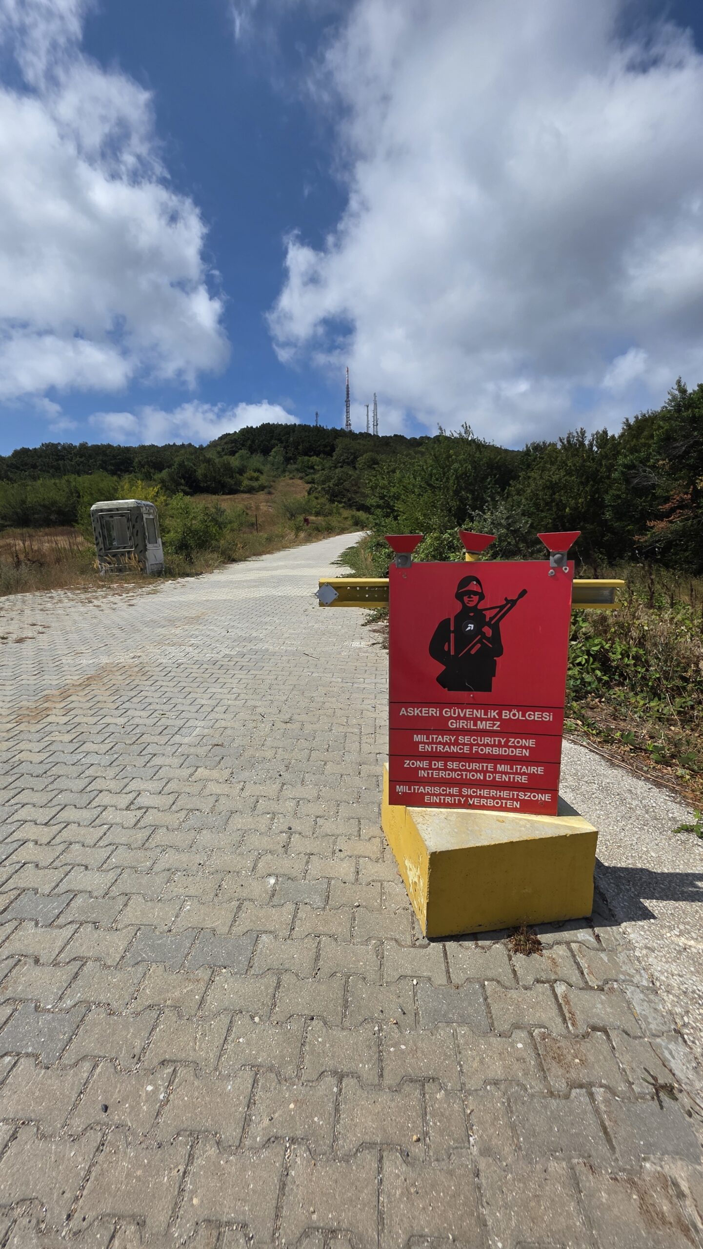
The day was hot and clear. The woodland and the quiet felt different from the more strenuous climbs of the journey. After a few photographs I returned to the car and drove towards Istanbul for the next stage.
I did not enter the restricted summit. Do not treat my stopping point, route or circumstances as permission for a future visit.
Questions answered
Is Mahya Dağı the highest mountain in Türkiye?
It is the highest point in the European part of Türkiye, not the highest mountain in the whole country.
Can visitors reach the summit?
The summit area is reported as controlled. Confirm the current rules with the competent authorities and do not cross restrictions.
Is there a guaranteed public trail to the top?
This guide does not identify one. Choose a confirmed public destination and follow current instructions.
What can I visit instead?
Consider İğneada, Dupnisa Cave or the region’s towns, checking current access and opening separately.
Sources and current information
Research checked 2 November 2026. Rules, opening, weather and prices can change.
- Istranca Mountains visitor overview ↗ — Reported summit restriction; confirm locally
- Türkiye Ministry of Justice: military restricted areas law ↗ — General legislation; local classification must be confirmed
- GoTürkiye: Kırklareli nature ↗ — İğneada, Dupnisa and regional nature
- Kırklareli Provincial Culture and Tourism Directorate: caves ↗ — Dupnisa and seasonal cave access
- Kırklareli Provincial Culture and Tourism Directorate: places ↗ — Regional cultural and natural sights
- Turkish State Meteorological Service: Kırklareli ↗ — Official forecast; town conditions differ from uplands
- Türkiye 112 Emergency Call Centre ↗ — Emergency service
- Kırklareli Governorship ↗ — Local public authority
- Turkish State Railways passenger service ↗ — Check current rail services