
01 / Start here
Romania’s roof.
A wild journey before the first step.
Moldoveanu rises to 2,544 metres in the Făgăraș Mountains. The popular southern approach from Stâna lui Burnei is often described as the shortest route, but the remote, changeable access road is part of the challenge.
The summit matters; the deep green valleys, glacial terrain and long Carpathian ridges are the reason to travel. This guide separates my unusually late and fast August outing from the safer planning margin most visitors should use.

- Highest point in Romania
- 2,544 mMoldoveanu, Făgăraș Mountains
- My starting point
- Stâna lui BurneiSouthern approach through Valea Rea
- Trail sequence
- Red triangle → red stripe → red dotConfirm the current line on a map and signs
- My summit day
- 12 August 202515:30 start · 17:29 summit · about 19:00 return
- Normal planning
- A full mountain dayStart early; do not copy my late departure
- Emergency
- 112 / 0SALVAMONT0725 826 668
The two checks that come first: ask Salvamont Argeș about the access road and trail conditions, then read the dated ANM mountain forecast. Read official mountain-safety advice · Check the official forecast.
02 / The Valea Rea route
The shortest popular approach.
Still a serious mountain day.
| Stage | What to expect | Decision |
|---|---|---|
| Stâna lui Burnei → Valea Rea | Steep forest path, stream and waterfall terrain; red triangle | Start only with enough daylight for the whole return |
| Valea Rea → Portița Viștei | Open glacial valley and sustained ascent | Recheck weather, pace and turnaround time |
| Portița Viștei → Viștea Mare | Steep, loose and increasingly exposed ground; main ridge marking | Turn back if visibility, wind or footing deteriorates |
| Viștea Mare → Moldoveanu | Narrower rocky ridge and the Spintecătura section; red dot | Use hands where necessary and allow two-way traffic |
| Return | Reverse the known route or follow a separately researched circuit | Do not improvise a new valley late in the day |
Munții Noștri publishes the marked route and stage estimates. Treat them as planning references, not promises: stops, congestion, wet rock, visibility and individual pace can change the day considerably. Study the route description.
I went up and down via Valea Rea in roughly 3½ hours of elapsed time. That is a record of one outing, not a recommended schedule. Most visitors should protect a full day, begin early and agree a turnaround time before leaving.
03 / Reaching Stâna lui Burnei
The road can decide the day.
Check it before you commit.
Stâna lui Burnei is reached from the Nucșoara / Slatina side on a long unpaved forest-road approach. Surface damage, washouts, fallen material and restrictions can change after storms or maintenance. A map pin cannot tell you whether your vehicle should attempt it today.
Call for a current answer
Contact Salvamont Argeș shortly before the trip and ask where ordinary cars can currently reach, whether any section is closed, and where vehicles should be left. Recheck after heavy rain. Rental-company conditions still apply even if another driver says they managed the road.
Build a fallback into the day
Carry fuel, a charged phone, food and water before leaving the villages. If the road forces you to park lower, the extra distance belongs in the hiking plan. Do not consume the daylight buffer by repeatedly forcing a low car over damage.
My experience
The final road felt like the hardest logistical part of my visit. I remember approximately 20 kilometres of very rough driving and a journey that seemed endless. That is my August 2025 experience—not a current road report or a guarantee of today’s distance and condition.
Find Salvamont information · Check official traffic notices.
04 / Forest, falls & stream
A steep beginning.
Water and rock set the rhythm.
The red-triangle route rises quickly through dense forest and beside the watercourses of Valea Rea. It feels enclosed at first, with glimpses of the rock walls above.

Roots, wet stones and stream crossings deserve deliberate footwork. A crossing that looks harmless in dry weather may be very different after rain. If water is high enough to make a safe return uncertain, the summit is not worth forcing.

Photograph waterfalls from stable ground and keep the path clear. The lower section is also where it helps to look back: forest junctions can feel less obvious on descent or in fading light.
05 / The upper valley
The forest falls away.
The Făgăraș scale appears.
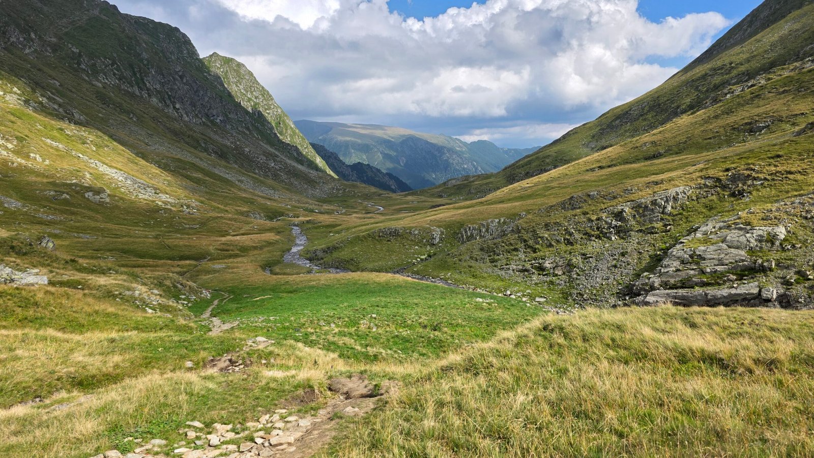
Above the trees, Valea Rea opens into grass, rock and glacial hollows. The landscape becomes easier to read in clear conditions, but cloud can erase those large visual references quickly.

Use the open ground as a checkpoint
Eat, drink and compare your progress with the turnaround time before the steeper climb. Look behind you and identify the return line into the valley. Continue only if the group has energy for the ridge and the complete descent.
Water is not an automatic promise
The photographs show streams during my visit. That does not prove flow or safe drinking water for another date. Carry enough for the day or use a treatment system you understand, and never make a critical refill dependent on an unverified source.
06 / Viștea Mare
The climb becomes sharper.
Loose stone demands attention.
The route steepens towards Portița Viștei and Viștea Mare, Romania’s third-highest summit at 2,527 m. This is where a long walk becomes a high-mountain ridge outing.

Leave space between walkers so dislodged stones do not hit the person below. On descent, shorten your stride and avoid overtaking where the trail narrows. Wet grass and loose rock can be more difficult than the same slope appears in a dry photograph.
Viștea Mare is not just a waypoint to rush through. It is a real summit and the place to reassess wind, visibility and remaining daylight before committing to the connecting ridge.
07 / Moldoveanu summit ridge
Across the notch.
Onto Romania’s highest point.
From Viștea Mare, the marked connection crosses the rocky Spintecătura Moldoveanului section before the final rise to Moldoveanu. The terrain is short compared with the valley approach, but it concentrates exposure, scrambling and two-way traffic.

Move one problem at a time
Put away loose items, keep three points of contact where useful and wait at a stable place for oncoming walkers. If the rock is wet, icy or hidden by cloud, the risk changes; a summit being close does not make turning back a failure.


Share the marker, step away for food and look across the ridges. The summit photograph is a moment; enough light and concentration for the descent are the real priorities.
08 / Descent choices
Reverse what you know.
Or research the circuit completely.
The simplest plan is to return by Viștea Mare and Valea Rea. A published circuit continues towards Roșu, Galbena and Lacul Galbena before returning to Stâna lui Burnei, but it is not an improvised shortcut.
| Return | Advantage | What to check |
|---|---|---|
| Out and back via Valea Rea | Known terrain and familiar junctions | Loose descent, stream conditions and forest navigation |
| Galbena circuit | New scenery and less repetition | Complete marked line, added distance, weather and daylight |
| Traverse to the north | Multi-day Făgăraș journey | Huts, reservations, transport and a completely different endpoint |
Before leaving the summit, eat, add a layer if needed and confirm the first correct marker. Tell your contact when you are safely back at the trailhead—not merely when you reach the top. Review the published circuit.
09 / Longer routes
Podragu and Sâmbăta.
See more than the shortest line.
Moldoveanu can be reached from the north and as part of a Făgăraș ridge journey. These alternatives trade the difficult Stâna lui Burnei road for longer walking and more involved accommodation and transport planning.
Via Podragu
A hut-based northern approach makes sense for walkers who want a longer Carpathian experience. Confirm the hut’s season, booking, meals, payment and route conditions directly; do not rely on an old blog for a bed.
Via the Sâmbăta valley
This is another substantial northern approach and usually part of a long or multi-day plan. Research every stage, the actual accommodation status and the return transport before setting out.
I did not walk these approaches on this trip, so they are presented as route choices to research, not first-hand descriptions. Check the hut’s current status with Salvamont and compare the complete marked approaches on the map. Compare the marked approaches.
10 / Guide or independent?
Choose for the conditions.
Not for the badge.
Experienced summer hikers may plan the marked Valea Rea route independently in stable conditions. A qualified local guide can be valuable for unfamiliar terrain, mixed-experience groups, early/late-season conditions or a complex traverse.
Before booking, agree the start and finish, route, maximum group size, expected duration, transport, equipment, weather policy and whether the fee is per person or for the group. Ask which professional qualification and insurance apply.
A driver to Stâna lui Burnei solves road logistics, not mountain leadership. Treat transport and guiding as separate services unless the provider explicitly includes both.
11 / Getting to the region
Choose the mountain side first.
Then choose the transport.
For Valea Rea, Curtea de Argeș and Nucșoara form the practical southern side. For northern routes, Victoria, Sâmbăta de Sus or the Olt valley may be more useful. They are not interchangeable bases.
| Plan | Best use | Missing piece |
|---|---|---|
| Hire car from Bucharest / airport | Flexible regional travel | Current forest-road condition and rental restrictions |
| Train to Curtea de Argeș | Reaching the southern region | Pre-arranged onward road transfer |
| Train towards Ucea / Făgăraș | Northern-side itinerary | Local transfer and longer mountain route |
| Guided transport package | One booking for logistics | Exact vehicle endpoint, inclusions and return |
Search live connections for the actual date. A station name in a timetable does not create public transport to Stâna lui Burnei. Search official rail connections.
12 / Driving & parking
Protect the vehicle.
Protect the daylight.
Fill up before the remote approach and download the road route offline. Carry a usable spare wheel or repair kit, know the rental breakdown procedure and avoid arriving with a low fuel level or a nearly empty phone.
Do not follow a summit pin
Navigate to the verified access point, not directly to “Moldoveanu”. Compare the driving route with the same current information you received from Salvamont.
Park for the return
Use the established parking area or current local instruction without blocking forestry access, bridges or turning space. Save the vehicle location and leave enough room for emergency services.
Check CNAIR notices for national roads · Check Romanian Police traffic information.
13 / Public transport
Possible to the region.
Not to the remote trailhead.
CFR’s journey planner can be used for dated rail connections, including services involving Curtea de Argeș. Timetables change, and the last segment to Valea Rea still requires a confirmed transfer.
Ask a provider in writing where pickup occurs, whether the vehicle can reach the current road endpoint, the return time, waiting policy and full price. If the mountain day runs late, know what happens before you set off.
A north-side route may suit a rail-based trip better, but it is a different and longer hike. Do not combine the easiest transport description with the shortest hiking description unless they actually meet at the same trailhead.
14 / Where to stay
Sleep near the right side.
Remove pressure from the morning.
| Base | Why use it | Ask before booking |
|---|---|---|
| Curtea de Argeș | Services, food and a cultural stop on the southern side | Early breakfast, parking and realistic drive to the current road endpoint |
| Nucșoara / Slatina area | Closer to the Valea Rea access | Exact location, road advice and evening food |
| Victoria / Sâmbăta side | Suitable for northern approaches | Transfer to the selected trail and hut plan |
| Mountain hut | Multi-day Făgăraș experience | Booking, opening, bedding, meals, water and cash |
Do not book by town name alone. Open the accommodation on a map and compare it with the side of the mountain you intend to use.
15 / When to hike
Summer is the simplest season.
Never a guarantee.
For a normal hiking itinerary, use the snow-free summer window and verify conditions close to departure. Early summer can retain snow; autumn brings shorter days and the chance of frost or early snow. Winter turns Moldoveanu into a mountaineering objective with avalanche terrain.
Do not choose a month as a substitute for a forecast. Even in August, cloud, wind, lightning and heavy rain can make the ridge inappropriate. After storms, the access road and stream crossings may also change.
16 / Weather & turnaround rules
Read the mountain forecast.
Make the decision before the ridge.
Check ANM’s forecast and active warnings the evening before and again on the morning. Look at precipitation, thunderstorms, wind, temperature and cloud—not just a sunshine icon for the nearest town.
- Turn around for thunder risk before committing to the high ridge.
- Do not enter cloud on exposed ground if navigation or confidence is inadequate.
- Allow the slowest person enough time for the full descent.
- Make a latest turnaround time and keep it even if the summit looks close.
My clear, mild afternoon in August was unusually forgiving. It is not evidence that a 15:30 start is sensible for another visitor. Read current official warnings.
17 / Water & food
Carry the day.
Treat streams as conditional.
Bring enough water for the climb and descent, adjusted for heat, pace and group needs. Streams may be contaminated, low or awkward to reach. If you intend to refill, carry and understand an appropriate treatment method.
Eat before the steep ridge, then keep a reserve for delays. Useful foods are easy to eat in wind or while moving: sandwiches, fruit, nuts and compact snacks rather than one meal that requires a long stop.
There is no summit café. Buy supplies before the remote road and keep emergency food separate from what you expect to consume.
18 / Terrain & safety
Prepare for loose rock.
Leave a clear rescue trail.
Salvamont advises hikers to use appropriate equipment, tell someone their route and call 112 or 0SALVAMONT when help is needed. Give your name, what happened, how many people are involved, when it happened and the location.
Download the Salvamont app if it suits your phone, but do not rely on continuous reception. Carry a headlamp, insulation, waterproof layer, first aid, emergency blanket, charged power bank and navigation you can use offline.
If someone is injured, protect the group from further danger, keep the casualty warm and follow the dispatcher’s instructions. Do not move a seriously injured person simply to regain the route unless remaining is immediately unsafe. See the official Salvamont app · Romania 112.
19 / The Făgăraș landscape
Glacial valleys and long ridges.
Travel gently through them.
The southern Făgăraș combine forested valleys, alpine grassland, streams and a high rocky spine. My photographs move through those layers in only a few hours; a slower itinerary reveals much more.
Stay on the marked line where erosion is visible, carry out every item and keep noise low. Do not feed animals. Romania’s mountains include large wildlife: give animals distance, keep food controlled and follow current local advice rather than seeking a close photograph.
The landscape is not scenery placed around a summit record. It is the main travel experience—and the best reason to return on a longer route.
20 / Curtea de Argeș
A cultural day below the mountains.
Not just a place to refuel.
Curtea de Argeș is a natural southern base with one of Romania’s best-known monastic monuments. Check the monastery’s current visitor information and dress respectfully for an active religious site.
Nearby Poenari Fortress is a separate excursion with a steep stair approach and access that can change. Verify that it is open before building the day around it.
After the mountain, choose one thoughtful visit and a proper meal rather than racing through several landmarks. Curtea de Argeș Monastery · Check Poenari Fortress information.
21 / Transfăgărășan & Bâlea
A road across the range.
A separate weather-dependent day.
The DN7C Transfăgărășan is the famous crossing of the Făgăraș, but its highest road section is seasonal and can close for snow or dangerous weather. Check official CNAIR and police notices on the day; do not quote an annual opening date as a guarantee.
Bâlea Lake gives access to high scenery and busy trails. It is not the starting point for the Valea Rea route and should not be squeezed into the end of an exhausting summit day.
A good longer trip can pair Moldoveanu with Curtea de Argeș and a separate Transfăgărășan day, keeping enough flexibility for mountain weather.
22 / Trip itineraries
One mountain day.
Two days for the region.
| Time | Plan |
|---|---|
| Arrival afternoon | Reach the southern base, buy supplies, confirm road/trail conditions and sleep |
| Summit day | Start early, hike Valea Rea, use a fixed turnaround time and rest after the drive out |
| Extra day | Curtea de Argeș and one nearby sight, or the Transfăgărășan if officially open and weather suits |
| Three-plus days | Consider a northern hut approach or a wider Făgăraș itinerary instead of only the shortest route |
If the forecast is poor, move the climb to the better day. A flexible cultural or road itinerary is far easier to rearrange than a ridge during lightning.
23 / Who is this hike for?
Fit walkers with mountain judgement.
Not a first walk because it is “short”.
The Valea Rea approach suits hikers comfortable with sustained ascent, steep loose ground and a short scrambling ridge. The remote access increases the consequences of a late finish or vehicle problem.
For children or mixed groups, judge the actual person’s recent mountain experience and comfort with exposure. A lower-valley walk can be a better family day than turning the summit into an obligation.
Train with consecutive climbs and descents, not only flat distance. The descent from Viștea Mare often reveals fatigue that was hidden by summit excitement.
24 / Packing & saved checklist
Pack for the delay.
Tick it off before the road.
Your ticks stay only in this browser. Winter or snow-covered conditions require a different technical list and the skills to use it.
25 / Costs & calculator
Use real quotes.
Calculate in Romanian lei.
Prices change too quickly for a responsible fixed budget. Enter current quotes in RON. The calculator divides only the shared vehicle and main travel totals; all other entries are per person.
26 / Maps, contacts & emergencies
Save the line.
Make your return known.
Use a current topographic hiking map and download the complete route, not only the summit pin. Munții Noștri provides Romanian trail mapping; compare it with signs and current Salvamont advice.
Emergency: call 112 or 0SALVAMONT at 0725 826 668. State who you are, what happened, how many people need help, when it occurred and your location. Stay available for instructions and conserve phone power.
Open the hiking map · Read Salvamont recommendations · Romania 112.
27 / Photography notes
Show the whole route.
Not only the flag.
The forest and waterfall photographs explain the steep beginning; the reflective stream and wide valley show the change in scale; the summit portrait completes the story. Place the images through the guide in that same sequence.
Vertical frames work well for the enclosed path and steep approach. Use a wide landscape image for the upper valley. On the ridge, make photographs from stable ground and put the phone away for scrambling or oncoming traffic.
Clouds over the Făgăraș add depth, but watch for the real weather they represent. A good photograph never outranks a safe descent.
28 / My August climb
A perfect climb.
After a nightmare road.
Moldoveanu followed a long journey from Ukraine and a small car-key battery that almost stopped the trip before Romania had properly begun.
The border problem
After travelling 92 kilometres by bus from Kozmechyk to the Solotvyno border, I reached the car and found the key battery dead. I stayed in a hotel, replaced it the next morning and finally began the long drive—about 565 kilometres—to the mountain.
Across Transylvania
The drive was beautiful, but the approach to Stâna lui Burnei became the “road from hell” in my memory: rough, slow and mentally exhausting. By the time I parked, the logistics had demanded more patience than the climb.
A 15:30 start
I set off at 15:30 on 12 August 2025. The air was mild, the sky mostly clear and the valley surprisingly quiet. I moved quickly through the forest, past the water and into the open grassland.
The route became steeper towards Viștea Mare, then narrower and rockier across the final connection. I felt strong and calm—exactly what had been missing earlier in the journey.
17:29 on Moldoveanu
I reached Romania’s highest point at 17:29. The flags moved gently, the ridges stretched into the distance and for a few minutes the difficult road disappeared from my thoughts.
I descended the same way and was back around 19:00. The climb itself had been almost perfect; access had been the truly difficult part.
A 15:30 departure left little margin for injury, navigation problems or changing weather. Use my story as a diary, not as a plan. Start early and protect the whole return.
29 / Questions answered
The useful questions.
Is Moldoveanu the highest mountain in Romania?
Yes. Moldoveanu reaches 2,544 m in the Făgăraș Mountains.
What is the shortest popular route?
The southern route from Stâna lui Burnei through Valea Rea is widely used as the shortest popular approach, but the remote road access is a major planning issue.
How are the trails marked?
The common sequence is red triangle through Valea Rea, red stripe on the main ridge and red dot for the Viștea Mare–Moldoveanu connection. Verify the current route on a map and signs.
Can a normal car reach Stâna lui Burnei?
Conditions change. Ask Salvamont Argeș shortly before travelling and follow rental restrictions. Do not rely on an older trip report.
How long should I allow?
Protect a full mountain day and start early. Published stage estimates are references; your group, road endpoint, weather and trail conditions determine the real time.
Should I copy Adrian’s 15:30 start?
No. It is part of my personal story, not a recommendation. Most walkers need a much earlier start and a generous buffer.
Is the summit route technical?
In dry summer conditions it is a hiking and scrambling route, but it includes steep loose ground and a narrower rocky connection. Snow, ice or storms change the objective completely.
Can I refill water in Valea Rea?
Streams may be present, but flow and quality are not guaranteed. Carry enough or use a treatment system you understand.
Can I use public transport?
You can reach the wider region by rail, but Stâna lui Burnei needs a separate confirmed road transfer.
Is there a longer alternative?
Yes. Northern approaches via Podragu or Sâmbăta and multi-day ridge itineraries offer a fuller Făgăraș experience.
What currency does the calculator use?
Romanian lei (RON). Enter your own current quotes.
What is the emergency number?
112. You can also call 0SALVAMONT at 0725 826 668.
What else should I visit?
Curtea de Argeș, Poenari Fortress when open, and a separately planned Transfăgărășan / Bâlea day are natural additions.
30 / Official links & sources
Your Moldoveanu planning desk.
Research checked 2 November 2026. Personal expedition record and all photographs: Adrian Mazur, 12 August 2025. Current access, restrictions, forecasts and prices must be rechecked for the actual travel date.
Official Romanian rescue, weather, emergency, transport and road sources are prioritised. Munții Noștri is used for the detailed marked route; confirm that description against current field information.
Preparation, route communication, emergency details and 112 / 0SALVAMONT
National mountain rescue information and regional contacts
Official safety application and SOS location tools
Official forecasts and mountain conditions
Current warnings; always read the issue and expiry time
Mountain forecast and Făgăraș snow/avalanche bulletins when issued
Marked route sequence, estimated stages and terrain notes
Alternative return through Roșu, Galbena and Lacul Galbena
Topographic map and marked Romanian hiking routes
Check current rail connections and buy tickets
Official national-road notices and restrictions
Current road incidents and closures
National emergency number and service information
Regional culture and visitor information
Official visitor and heritage information
Official information for the fortress; verify access before travelling
National destination information for planning a wider trip