
01 / Start here
Start here.
Triglav, at 2,864 m, is the highest mountain in Slovenia. From Krma Valley, a long approach leads toward Kredarica and an exposed, partly secured summit route. The final terrain is a serious alpine undertaking rather than an ordinary walk. National Park safety guidance.


02 / Krma Valley route
Krma Valley route.
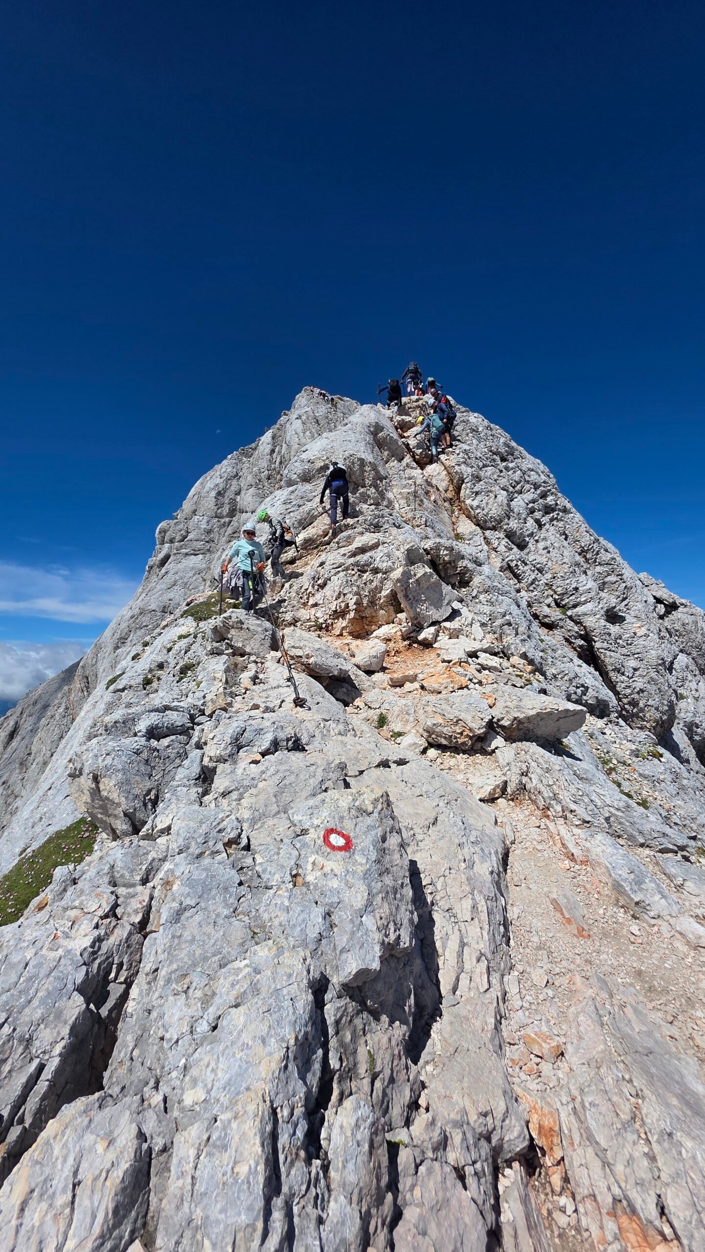
From the Krma trailhead the marked route passes forest and the Vrtača and Zgornja Krma areas, then climbs toward Kredarica. Above the hut, steep secured ground leads to Mali Triglav and the exposed ridge toward Triglav. The Slovenian Mountaineering Association describes this as a very difficult marked route, with about 1,980 m of ascent and an eight-hour ascent estimate. Allow additional time for the descent; conditions and group pace vary. PZS route description.


03 / The summit ridge
The summit ridge.
The summit approach includes exposed rock, steel cables and iron protection in places. A fall can have serious consequences. The national park recommends a helmet, harness and self-protection kit on very difficult routes; know how to use them. Trail difficulty guidance.

04 / Kredarica hut
Kredarica hut.
Triglavski dom na Kredarici is a high mountain hut near a summit approach. Check the Mountaineering Association for current operation, reservation requirements and facilities. A hut stay can split the long ascent, but the summit remains exposed. Mountain huts.
05 / Other approaches
Other approaches.
Triglav has several approaches with different distances and technical demands. A route from Krma must not be confused with a north-face climbing route or another valley approach. Compare current maps and seek local expertise.
06 / Mountain safety
Mountain safety.
Check forecast and trail reports, start with sufficient daylight and agree on a turnaround time. Thunderstorms, wet rock or snow can make the ridge hazardous. If uncertain about the terrain or protection, choose a qualified guide. National Park safety.
07 / Using a guide
Using a guide.
A qualified mountain guide can assess current conditions and teach or manage protection on the secured route. Discuss experience, group size, equipment, route and cancellation terms. Slovenian Mountain Guides.
08 / Fitness
Fitness.
The Krma approach involves a long ascent and descent. Develop endurance on demanding mountain days and allow time for the slowest person. Good fitness does not replace experience on exposed ground.


09 / Time on the mountain
Time on the mountain.
Allow a full day or split the climb with a hut, depending on route, fitness and conditions. My recorded statistics were 19.13 km and 1,986 m gain; my original account contains inconsistent return timing, so these are personal data rather than a recommended schedule.
10 / Weather
Weather.
Summit weather can differ greatly from the valley. Check wind, storms, temperature and visibility immediately before leaving and turn back when conditions deteriorate. Slovenian weather service.
11 / Snow and ice
Snow and ice.
Snow can remain on high paths into summer and return early. A protected route covered by snow or ice may require mountaineering equipment and skills beyond ordinary via ferrata practice. Ask local experts before starting.
12 / Equipment
Equipment.
Carry a helmet, suitable mountain boots, waterproofs, warm layers, food, water, first aid, navigation and a headlamp. A harness and appropriate via ferrata self-protection kit are recommended for very difficult secured trails; learn their use first.
13 / When to go
When to go.
High-mountain conditions, hut openings and snow vary each year. Ask huts and guides for current information and avoid assuming that a summer date guarantees a safe ridge.
15 / Getting there
Getting there.
Mojstrana is a practical gateway to the Krma area. Check current buses, transfers, road access and the final connection to your precise trailhead. A train connection alone does not guarantee transport into the valley. Slovenian Railways.
16 / Parking
Parking.
Triglav National Park asks visitors to use designated spaces and recommends Kurja vas before entering Krma. Its published map also lists marked areas in the valley. Check current access and restrictions, which can change. My 2025 account is not a promise of free parking. National Park parking notice.
17 / Where to stay
Where to stay.
Mojstrana and the wider Upper Sava Valley provide bases, while a reserved mountain hut may help divide the route. Check opening, transport and cancellation arrangements.
18 / Food and water
Food and water.
Carry sufficient food and water with a reserve for delays. Check hut opening before depending on meals or water, and do not assume natural water is safe to drink.
19 / Sharing the route
Sharing the route.
The summit approach can be busy. Avoid dislodging rocks, allow parties to pass where safe and keep enough time to descend without rushing. A queue does not mean the route is suitable for your group.
20 / The Aljaž Tower
The Aljaž Tower.
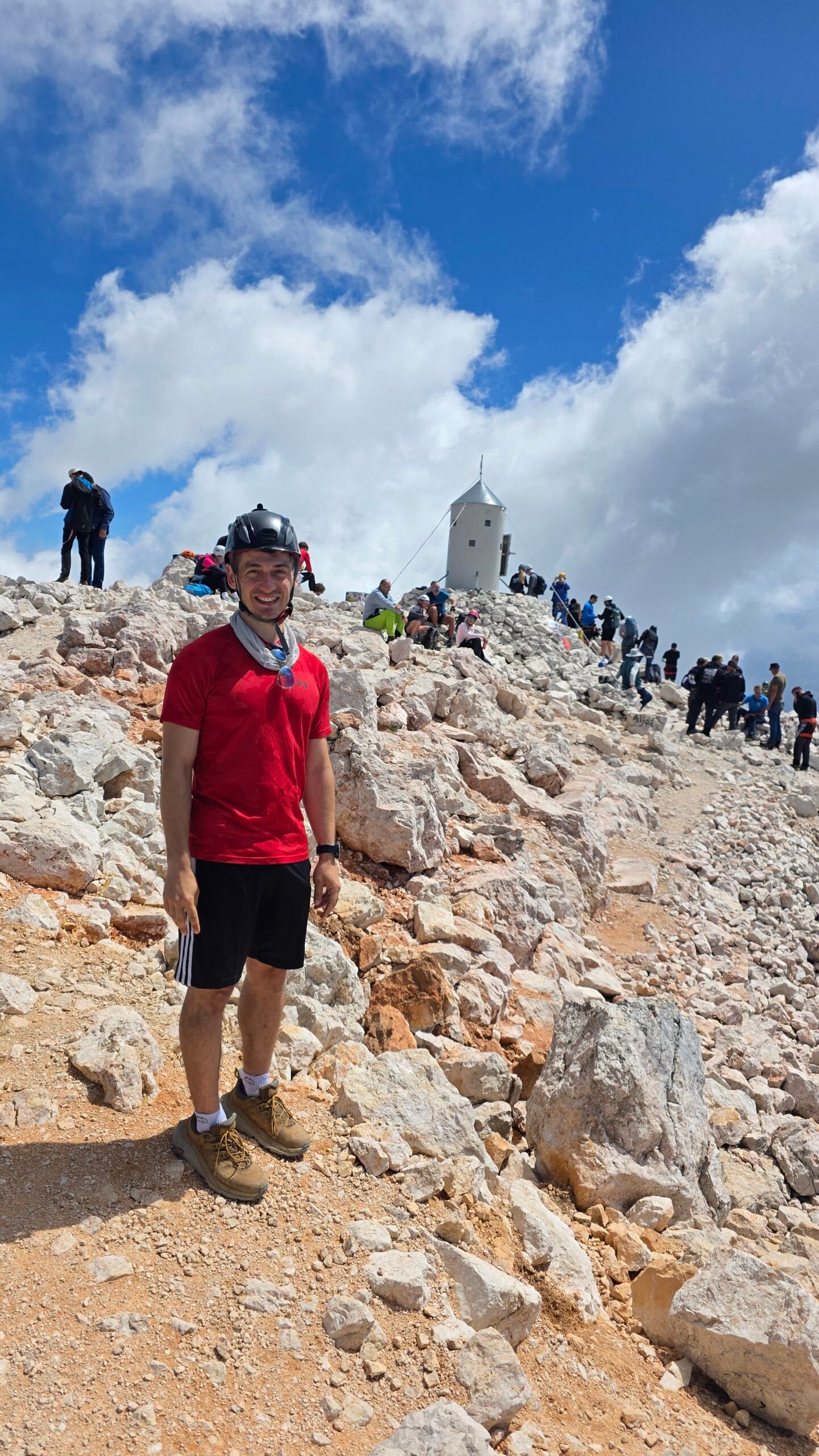
The small Aljaž Tower stands on Triglav and is a well-known Slovenian mountain symbol. Treat the summit and the people around it with care, especially on crowded days.

21 / National park
National park.
Respect protected habitats and closures, take rubbish away and stay on designated routes. The park says overnight stays outside designated areas are not permitted and drone use in the natural environment requires prior consent. Park visitor rules.
22 / Emergency
Emergency.
In Slovenia call 112 and provide your location, situation and the number of people. Rescue may be delayed by storms or poor visibility; a charged phone is not a substitute for a plan.
23 / A practical itinerary
A practical itinerary.
Arrive in the region, check weather and current trail information, and consider a reserved hut to break up the climb. Keep a weather alternative and enough time for the descent.
24 / Costs
Costs.
Allow for travel, parking, food, a hut, optional guiding and equipment. The calculator uses your own current euro amounts rather than live prices.
25 / A lower alternative
A lower alternative.
If the high ridge is unsuitable, ask park staff about an open lower-level route in the Julian Alps. Respect closures and choose an outing appropriate to your group. Park visitor information.
28 / Saved checklist
Prepare for an exposed alpine summit.
Saved only in this browser. The final summit route is exposed and protected in places. Check conditions, use appropriate protection and consider a qualified mountain guide.
29 / Cost calculator
Use your own quotes.
Plan in euros.
Enter your own current prices in EUR. Vehicle and main travel are shared; the other amounts are per person. Include any park, guide and transfer quotes under the appropriate fields. Blank entries count as zero.
My story, FAQ & sources
A clear day in the Julian Alps.
On 18 July 2025, after an overnight journey from San Marino and a short rest in the car, I started from Krma Valley around 08:00. The forest gave way to bright alpine scenery on the way toward Kredarica.
I reached the summit around 12:10 in clear, calm weather. The Aljaž Tower and the layers of the Julian Alps made the long climb memorable. My device recorded 19.13 km and 1,986 m of ascent; my original notes contain conflicting return times, so I have left the exact time open.
After the descent I met my father and enjoyed a meal together. The clear conditions were fortunate, not a promise: the ridge demands careful preparation and appropriate protection.
Frequently asked questions
How difficult is Triglav from Krma?
The Slovenian Mountaineering Association describes the Kredarica route as very difficult; the final ridge is exposed and partly secured.
How long does the climb from Krma take?
PZS gives about eight hours for the ascent on its described route; add the descent and allow for your group and conditions.
How much ascent is involved?
PZS lists roughly 1,980 m of ascent for its described Krma route.
Can I climb it in a day?
Very fit, experienced parties may, but a reserved hut can divide the long day; the exposed summit remains challenging.
Is Krma the easiest approach?
Slovenian tourism describes it as the easiest of the three northern-valley approaches, but also the longest; the summit remains exposed.
What is the route through Kredarica?
The marked approach passes Zgornja Krma toward Kredarica, then climbs to Mali Triglav and the final ridge.
Do I need a helmet?
The National Park recommends a helmet on difficult and very difficult mountain paths.
Do I need a harness and via ferrata set?
The park recommends a harness and self-protection kit on very difficult trails. Know how to use the gear before starting.
Are fixed cables continuous?
Protection varies by section and condition. Do not assume every exposed section has a continuous cable.
Should I hire a guide?
Choose a qualified mountain guide if your experience on exposed secured terrain is insufficient.
Where can I reserve Kredarica?
Use the hut or Mountaineering Association information and confirm availability, terms and current service.
Is there water at the hut?
Supplies can change. Ask the hut directly and carry sufficient water for your route and delays.
Can I sleep in my car in Krma?
The National Park does not permit overnight stays outside designated areas. Confirm local rules and use authorised accommodation.
Where can I park in Krma?
Use designated spaces; the National Park recommends Kurja vas before the valley and lists marked parking areas. Check current restrictions.
Can I fly a drone?
The park says drone use in the natural environment requires its prior consent. Check current rules and any other airspace restrictions.
Can snow remain in summer?
Yes. Snow or ice on secured terrain may require additional mountaineering skills and equipment.
Can I take a dog?
Dogs must be on a lead in the park; the exposed, steep summit route may be unsuitable. Consider the animal and other climbers.
What if a thunderstorm is forecast?
Avoid the exposed ridge, change plans and follow current forecasts and local advice.
What is the emergency number?
Call 112 in Slovenia and provide your location.
How far did Adrian record?
His device recorded 19.13 km and 1,986 m of ascent; this is personal data, not a guarantee for another route.
When did Adrian climb?
18 July 2025. His original notes have conflicting return times, so the exact return time is not asserted.
Sources and current information
Research checked 2 November 2026. Conditions, access and prices can change.
- Triglav National Park: mountain safety ↗ — Route grading and protection
- Triglav National Park ↗ — Park access and notices
- Mountaineering Association of Slovenia ↗ — Mountain huts and trail information
- Slovenian Mountain Guides Association ↗ — Qualified mountain guides
- Slovenian Environment Agency ↗ — Weather and warnings
- Slovenian Railways ↗ — Train travel
- Mountaineering Association of Slovenia: Krma to Triglav ↗ — Route description, difficulty and ascent time
- Triglav National Park: Krma parking ↗ — Designated parking areas
- Triglav National Park: visitor rules ↗ — Camping, drones and environmental rules